Blog
40 Acres and a Mule?
If we take a quick look back to 1791 to 1831, Governor Phillip (and later Governor Macquarie) issued free grants of land on behalf of the Crown to encourage settlement of the State of NSW.
Over time, legislative advancements reflected the economic, social and environmental needs of land management. In 1825 the system of selling land in NSW was introduced, leading to the abolition of free grants for Crown land in 1831.
After 1831, land was only sold at public auction and the Governor's discretionary power of refusing applications for land ownership was abolished. That's right, You could only own land with the Governor's discretionary power!
The NSW Department of Lands and Public Works was launched in 1856 to cater for the expanding functions of the Surveyor General's office.
The Occupation Act 1861 (NSW) permitted any person to select up to 320 acres of land and purchase the freehold (with the exception of urban land). Prior to this, powerful squatters had managed to acquire huge tracts of NSW prime land through illicit occupation. The Occupation Act opened up these squatter held lands for selection by anyone in the colony.
One of the ways to obtain land was called a Conditional purchase which obtained a Crown Grant for land before it was surveyed. Established in 1861, the grant was dependent on a set of conditions being met. The purchase was conditional on:
- the area being limited to 40 to 320 acres at £1 per acre
- paying a deposit of one quarter of the purchase price
- adding improvements to the value of £1 per acre
- the selector residing on the land, and
- occupying the land for three years
It was also known as 'free selection before survey'.
The land available for purchase had to be a specified distance from populated areas. In effect Crown land was not available for conditional purchase if it was town or suburban land, within a proclaimed gold field, under lease to another person for mining purposes, or reserved for the site of a town, village or for water supply.
Pictured here is a survey from 1878. 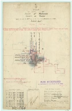
As mentioned, during this period all the grants were a minimum of 40 acres (usually with creek frontage), which were considered adequate space for a family to farm. The conditions of the grant were that the boundaries were fenced, home established and the family were actively farming on the land. America was similar but they were granted 40 acres AND a mule after the confederate fall in 1865. Unfortunately no mules were granted in Australia.
Of course all this history and “free selection before survey” lead to many grants of land being “bought” twice or placed on un-surveyable land. This is where surveyors really came into their own. Sometimes this meant that boundaries went up and over extreme terrain that couldn’t be physically accessed, and it was easier to survey due to the simple mathematics.
But these practices meant that it could be easier to move corner markers or correctly ensure land is correctly identified. One of the other options was reference trees which were blazed and numbered like the photo.
The surveyors initially used bush-cut pegs and posts as survey marks. In rocky outcrops, a drilled hole with cut wings were used. When the ground was too hard, pegs were inserted into a pile of rock. These can remain undisturbed for decades and usually are well-preserved.
Trenches were placed to indicate the direction of boundary lines from the peg. Another bit of surveying jargon; the word for these is “lockspits”, an archaic term defined as “a small trench cut to indicate the line to be followed in further work”. When the ground was too hard, piled stones were used and a new term was invented; “rockspits”.
Reference trees were cut to allow the re-establishment of a corner when the original mark was destroyed or lost. As trees can also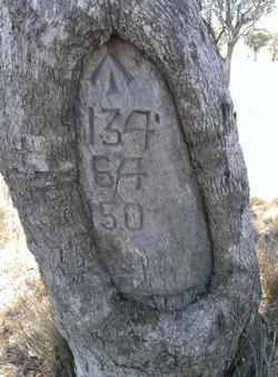 be lost from bushfire and general clearing, from the 1890s, special marks were introduced. These were galvanised iron pipes or bottles with ash from the campfire which were buried 5 links (1.006m) from the corner on the line of the boundary. To ensure they weren’t disturbed due to fencing, the special marks were placed 500mm below ground level. Nothing better than digging a hole under a mesh fence at an angle whilst trying to avoid breaking a 100 year old bottle!
In more recent times boundary corner reference marks have become the norm with corners easier to re-establish. Electronic distance measuring (EDM) instruments became prevalent in the 1980s supplanting the steel wire that had been used since the 1860s. Up until then, the link chain had been the standard tool for distance measurement with GPS being used since the 2000s.
Often we have to compare our GPS derived distances between corners with distances measured using a Gunter’s Chain, a steel wire and EDM. Whilst the distances between two corners may be different, the corners haven’t changed. We surveyors have been able to measure the distance a lot better than our forebears.
With increased technologies and the expertise of surveyors, we now have more accurate and reliable surveys and land allocation.
Thank God for surveyors!
